

Leica Hexagon MissionPro v12.9.0 (x64)

Leica Hexagon MissionPro v12.9.0 (x64) | 1.25 GB | Language: English
[spoiler]
Leica Geosystems Geospatial Solutions Division is pleased to announce today the release of its new mission planning software, Leica MissionPro 12.9.0. The software provides mission planning capability for all airborne sensors including LiDAR, line and frame sensors and is fully integrated into existing Z/I Imaging and Leica Geosystems workflows.
Leica MissionPro 12.9.0 release
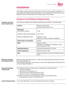
This is a full release of Leica MissionPro 12.9.0. This software release is only supported on Microsoft Windows 10 64-bit operating systems
Leica MissionPro 12.9.0 is released for the following sensor systems
– Leica ContentMapper
– Leica CityMapper-2
– Leica TerrainMapper-2
– Leica TerrainMapper
– Leica CityMapper
– Leica CityMapper with TerrainMapper option
– Leica DMC III
– Leica ADS100 with SH100/SH120
– Leica ALS80
– Leica RCD30
– Leica RCD30 Oblique
– Leica Topobathymetric Lidar systems:
. Leica Chiroptera-5
. Leica HawkEye III
. Leica Chiroptera II
. Leica DragonEye
– Leica SPL100 systems
Leica MissionPro 12.9.0 Features, Fixes, Changes and Open Issues
Leica MissionProis the mission planning software for all Leica Geosystems airborne sensors across multiple product generations. The unique 3D virtual globe interface and the advanced computation algorithms simplify and speed up your mission planning.
Leica MissionPro is a Software for mission planning for all types of sensors including Leica CityMapper, Leica TerrainMapper, Leica ADS100, Topobathymetric LiDAR systems, Leica ADS80, Leica ALS80, Leica ALS70, Leica RCD30, Leica RC30, Z/I DMC, Z/I DMC II, Z/I DMC IIe, Leica DMC III and any other film or digital frame, line or ON/OFF sensors.
Generate effective flight plans by selecting area, sensor and acquisition parameters. Evaluate the mission quickly and thoroughly right after execution, regardless of project size. Evaluate your flights, run quality control, prepare reporting and manage projects.
Leica Geosystems Airborne Bathymetric Solutions
Leica Geosystems 4X bathymetric product line increase the point density by factor 4 compared to previous versions. The airborne bathymetric LiDAR sensors provide seamless data from water to land and seafloor coverage of up to 50 m water penetration. Combined with Leica LiDAR Survey Studio they offer a complete solution for hydrographic surveying.
Hexagonis a global leader in digital reality solutions, combining sensor, software and autonomous technologies. We are putting data to work to boost efficiency, productivity, quality and safety across industrial, manufacturing, infrastructure, public sector, and mobility applications. Our technologies are shaping production and people-related ecosystems to become increasingly connected and autonomous – ensuring a scalable, sustainable future.
Product:Leica Hexagon MissionPro
Version:12.9.0
Supported Architectures:x64
Website Home Page :
Languages Supported:english
System Requirements:Windows *
Size:1.25 Gb
https://abload.de/img/249e2f15733e85bb9e16brd0j.jpeg
https://abload.de/img/1b37c9fbedac8853c501jhful.jpeg
[/spoiler]
Homepage: https://leica-geosystems.com/
DOWNLOAD LINKS:
https://k2s.cc/file/154c8a875fc20
https://nitroflare.com/view/EC3ECC0C2A86150/Leica_Hexagon_MissionPro_v12.9.0_x64.rar
https://uploadgig.com/file/download/7b57AE9667Fc569a/Leica_Hexagon_MissionPro_v12.9.0_x64.rar

